
|
|
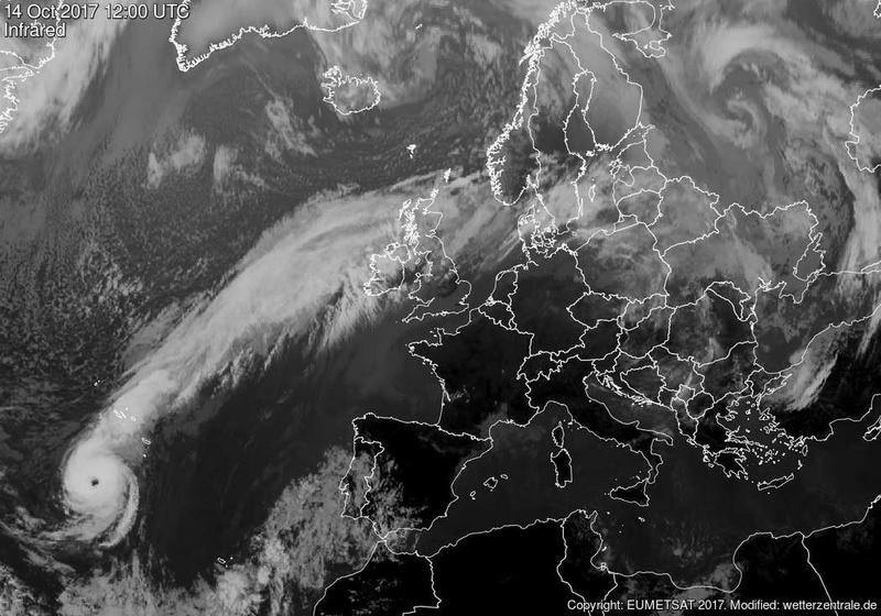
This was the most unusual and hyped up wind storm event I have ever experienced in my life. Hurricane Ophelia amazingly managed to sustain itself as it continued to make its way NE across mid latitudes where it was expected to weaken and decay into a typical Atlantic storm once it encounted cooler ocean temps, however this storm decided to throw away the rule book and run renegade across the Atlantic surprising every forecaster on the planet. Ophelia lost it's eye then suddenly developed a new eye with wind speeds on its flank at 200mph. As the storm exited warm seas it made a bee line for Ireland and although its strength was expected to weaken with time the storm boasted surprisingly stronger wind fields and organization than anyone had anticipated. Warm SSTs helped sustain the storm in conjunction with a strong jet stream rich in wind shear kept the storm alive. On it's current track the storm was expected to impact Ireland on October 16th early in the morning along the S coast of Ireland then travel NE across the country throughout the day bringing a risk of truly severe weather, this storm had already become historic being the most eastern placed hurricane ever recorded, it seemed this storm was full of life and was determined to show off what it could do.
 |
Suddenly everything went crazy, the news and social media was completely dominated by this rare storm, forecasters battled with wind strength predictions and it seemed everyone on facebook and twitter who previously had no interest in the weather were sharing warnings and chatting about this impending event. Forecast models predicted that the main danger area was the SW, S and SE coasts of Ireland where Ophelia would make landfall during the morning hours with hurricane force winds, large waves and even a risk of a storm surge, shipping forecasts mentioned 'phenomenal seas' and soon joint discussion between Met Eireann, Met Office, and National Hurricane Centre were taking place, the consensus was that no one knew for sure what was going to happen however the situation looked extremely dangerous to the public so within 24 hours Met Eireann had issued a very rare red warning for areas most at risk. 12 hours later the red warning was extended to cover the entire country of Ireland, this is something I had never seen before since I first became interested in storms, this was unprecedented, RTE and Met Eireann underscored the forecast by saying the storm posed a risk to life and that the public were warned to avoid all coastal areas and not to travel at all. The met Office had issued an amber warning for N. Ireland, then on the eve of Ophelia's arrival it was decided that all schools across Ireland and N. Ireland would be closed for two days.
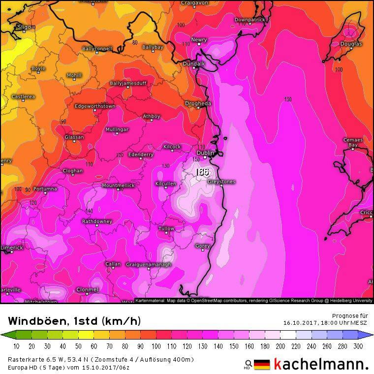 |
I was more than interested in documenting some aspect of this storm however I couldn't make it as far as the S coast, however as the low rotated the outer flank of the storm would wrap violent winds along the E coast of N. Ireland with hurricane force gusts whipping across the Irish Sea and impacting the SE corner of N. Ireland by mid to late afternoon with high resolution charts showing gusts of 150-160 km/hour. I decided that this was would be an excellent target area, first because severe to hurricane force winds were consistently showing in this area on every model run and second because despite being a good drive it would be a lot more assessable than the longer drive to Cork.
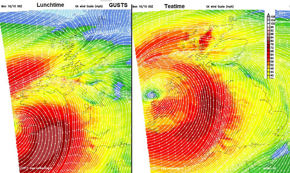 |
I hardly slept the previous night due to the excitement and anticipation of what the day would have in store combined with the excitement on social media about the storm's impact. Early in the morning I was awake in bed studying charts on the lap top at 06.00, the models confirmed my target area, S, SE and E coasts would be prime locations for destructive winds with lighter wind fields along the W and NW coasts associated with the proximity of the low pressure centre or 'eye', the W looked to be a major rain event however the E looked to be drier for a few hours which would give us a chance to undertake filming and take advantage of whatever light we got.
Roisin and I grabbed an early lunch and coffee in Cookstown then by late morning made our way SE to our target area in Co. Down. This trip was incredibly surreal, there was very little traffic on the roads, very few cars for a Monday morning and there were very few people around. Most of the shops were closing at midday then all civil servants were informed to stay home for the day including courts and large retailers, it seamed that much of the country was home and staying indoors. The roads, towns and villages were like ghost towns, I couldn't believe this was happening in N. Ireland, the atmosphere was rich in anxiety and anticipation. Roisin kept me updated on the latest news on social media as we made our way closer to our target area, we heard that 100,000 homes were already without power in the S and that three people had been tragically killed by falling trees, the news sobered us, this was for real.
Emergency services continued to warn the public not to travel unless it was absolutely necessary, however here we where heading into danger, for me it felt a natural impulse, when I hear about the potential for severe weather it's like a red flag to a bull, whether its thunderstorms, blizzards, flooding, waves and severe wind events I feel I need to be there to experience and document nature on camera, I wanted to be here today in the company of this storm, it was a part of weather history and I wanted to be a part of it. To be honest I was slightly worried for our safety, but only during the drive there and back due to aerial debris, falling trees and high side vehicles blowing over on the road (there were plenty of big lorries on the roads!), however once at the coast I knew we would be safe despite being face to face with stronger winds, we would be back far enough from the sea to avoid danger and there would be no debris, slates, trees or trucks to threaten us so we would be free to enjoy the view.
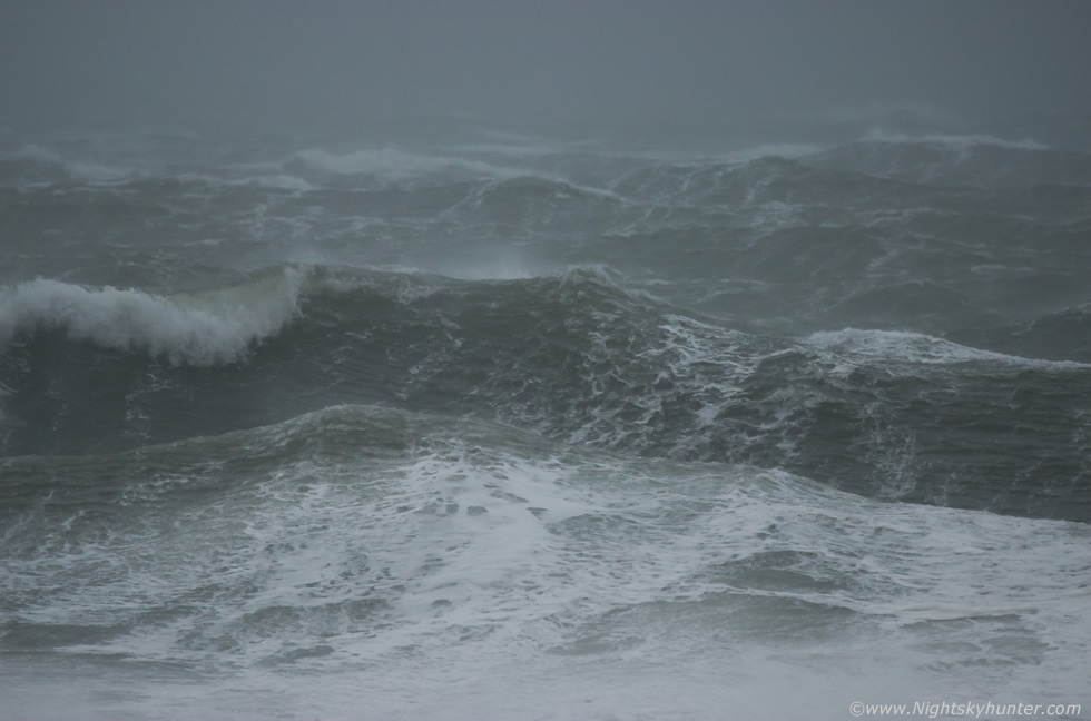 |
As we got closer to St. John's we got a glimpse of the Irish Sea and could tell there was serious wind on its surface, high speed white froth whipped across the waves blasting towards shore, the sight of it got us all excited. We passed isolated houses with their aerials broken and blowing horizontal in the air like wind socks. We arrived at St. Johns lighthouse, a location where we had never been before, the coastline was low and flat almost at sea level which accentuated the visual impact of the sea powering on shore. When we first arrived it was gusting greater than 50mph however with time the sustained wind seemed to increase in severity at an alarming rate, gusts were not just gusts, when they hit they seemed to last for many minutes without easing at all in complete contrast to a squall, the car doors were difficult to open (and close) at times and when outside we were getting blown off balance, then later we could lean into the wind at a 45 degree angle and stay supported by the sustained winds, taking steady video footage was absolutely impossible, my heavy Canon 100-400mm lens was getting buffeted continuously, it was like the storm was saying 'no paparazzi' but I did my best, at one stage we took shelter behind an outcrop of rocks, laying on my stomach, lens pointing through a avoid in the formation like an elemental sniper.
The sea was a seething mass of chaos and turmoil with multiple layers of waves all interacting and clashing in an evil looking cauldren of threatening high speed madness which was disturbing yet thrilling to watch. As waves rolled, crashed and churned severe winds lashed across the surface shearing tops and sending lumps of sea foam the size of bricks through the air past ours heads inland into the fields behind us, some of them whacked our lenses and faces followed by an almost overwhelming taste of salt, the only thing missing was a portion of chips. The sea state grew in height and intensity as the tide rose and as wind gusts reached their climax we were finding it difficult to walk forward at times which was an interesting experience, we kept our exposure to the wind to short adventures away from the vehicle then back for shelter again as too long outside was just too much to take, we could feel the wind cutting through all our layers of clothing. A few locals arrived and ventured out over the rocks to experience the wind and marvel at the ocean while taking selfies. The light was very low and dropping fast, the wind-whipped ocean spray and foam had formed a silver-grey wall over the sea like cloud which hampered light and with thoughts of the return trip home being more treacherous we decided to make our way back before last light.
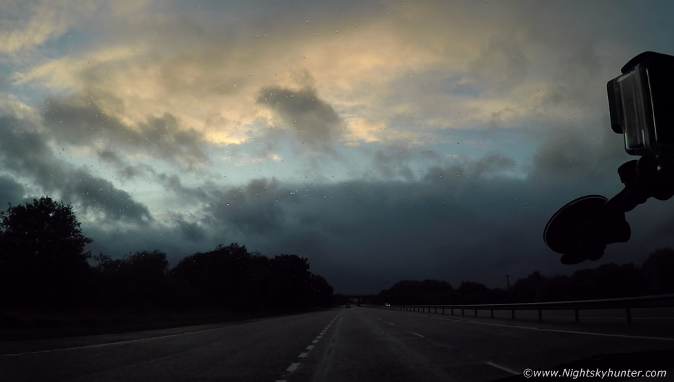 |
As we made our way back along the coast road we saw the same houses now with no aerials at all, the roads were covered in tree branches and debris while countless phone cables had been ripped away and left hanging from poles, the remaining phone lines which were still attached were bowing horizontally in the air ready to break at any moment, we spotted a heavy round bale of hay which had been blown across a level field up aganst a wire fence which had been buckled at the side of a road, that was something I had never seen before. Broken trees and sheared branches lined the road sides all the way back then when approaching Mid Ulster we drove straight under the 'eye' of the cyclone, this is something we had never seen before in our lives, this was once the eye of the hurricane which had transitioned to the eye or low pressure centre of this extra tropical storm, the following stills are from the Go Pro footage, this was facing the other side of the 'wall' where cloud and rain was dense, while above us the sky was clear and blue and behind us it was cloud once more, it was quite surreal.
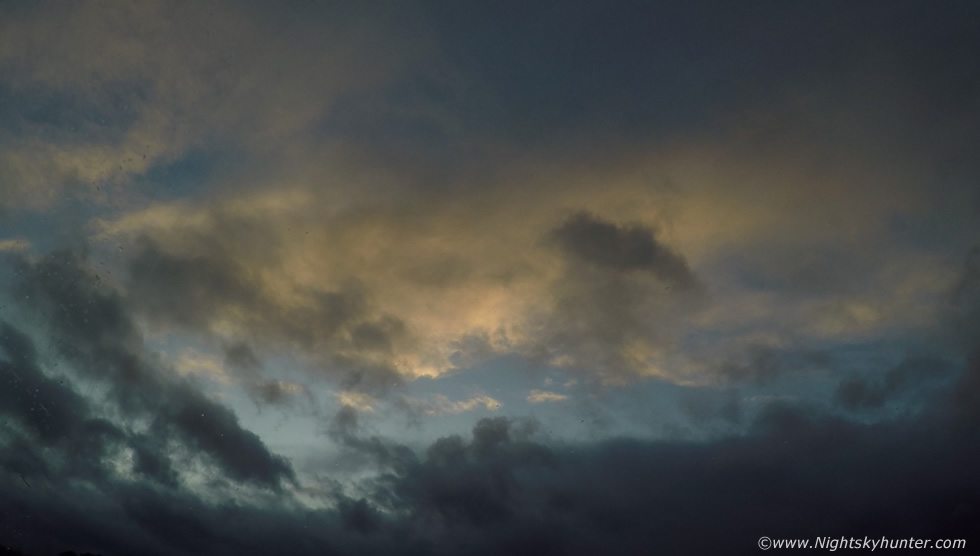 |
Camera panned up in to the 'eye', this sight made more of an impression on me than the sea, I have experienced severe winds and mad seas before however I have never witnessed the actual eye of the storm and never thought I would in Ireland so this memory stands up there on the list of rare events I've been lucky enough to experience and cherish. We made it back for 19.00 as darkness fell feeling content from the chase, I had seen larger waves than this and felt stronger winds however there was no question that it was certainly a severe rare event so it felt only fitting to have experienced it first hand. Later I found out that top wind speeds in the S where 120mph (well beyond hurricane force) and that wind gusts at our location exceeded 71mph making them borderline hurricane force, although I was informed of an even greater wind gust in the same area from another source in the 90mph range, a remarkable storm surge had been captured in the S which legendary US storm chaser Reed Timmer had shared on facebook putting Irish weather on the international stage, ocean buoys recorded maximum wave heights of 17.81m over the SE coast at 16.00 with one buoy breaking its mooring.
A compilation of the video footage I managed to obtain in these challenging conditions showing the sea state, flying foam and severe winds, we intercepted this storm at a strategic location placing ourselves in the severest winds we could find in N. Ireland, acquired video footage, and made it home safely, that is truly a successful days chasing indeed, thanks for reading.
Martin McKenna